Thursday 3 January – Wednesday 9 January
Richmond Alpine Track – Browning Hut to St Arnaud
Day: 79 – 85
Km’s: 98km
Cumulative km’s: 1,935km / 3,000km
Welcome to our second instalment from the Richmond Ranges!
As Leigh mentioned in the last post, the Richmond Ranges were definitely a step up in difficulty compared to anything we’ve run into on the trail to date. Whether it was the consistently scorching hot weather, the unrelenting steep mountain terrain, the goat tracks parading as an official ‘route’, or having to dodge agitated wasps, the Richmond Ranges was by far the closest we’ve come to real danger on the trail. That may well be a bit dramatic, but it certainly was the most challenging and diverse section of the trail to date. For all its challenges though, it was an absolutely stunning part of the trail that we both enjoyed immensely.
We’ve since heard that this is considered by some to be the most demanding section of the entire Te Araroa trail, so we’re feeling pretty good about the fact that we were able to get through it relatively unscathed. Our shoes weren’t so lucky though and will be carrying a few battle scars into the Waiua Pass section coming up next.
Day 79 – Thursday 3 January, 14km
Browning Hut to Slaty Hut
We made the decision to leave the tent fly open last night as it wasn’t too cold and it seems to help with reducing the number of sandflies stuck inside the rain fly of the tent, waiting eagerly to attack us on our departure from the safety of the inner tent. We promptly regretted that decision by the morning when we awoke to find the rain fly completely drenched in condensation. Must have been the fact that we were camped close to a river. Won’t make that mistake again.
After a poor attempt to dry some of the condensation from the tent, we packed up and were ready to leave by about 8am. We were conscious that the forecast was for high temperatures this week (up to 30 degrees some days) and we wanted to try and avoid walking in the hottest part of the day if possible. All that went out the window once we got chatting to the two ladies who had stayed in the hut opposite our campsite last night.
From travel and adventures to family and jobs, we chatted for a good two hours before finally deciding that we needed to start walking around 10am. They even left us with a parting gift of dried kiwi fruits that their mutual friend makes and gives to them for hiking trips.
We had been given a heads up that the track from Browning Hut to Hackett Hut was mostly downhill and pretty quick, which turned out to be accurate as we reached Hackett Hut in under an hour after a few minor river crossings.


This brought us to the end of the Pelorus River Track and to the start of the Richmond Alpine Track. The trail from Hackett Hut to Starveall Hut would be steep in many parts as would see us climb up through the forest to the top of the tree line.

After smashing down a quick lunch at Hackett Hut while being swarmed by sandflies and curious bumblebees, I headed off to catch up with Leigh who had already started walking towards the hut.
Before climbing though, the track would send us across numerous creek crossings. The beautiful setting almost made you forget about the fact that your feet were soaked through.

By the time I caught up with Leigh, she had stopped for lunch on the trail near a small stream. In need of cooling off from the climb, I took the opportunity to dunk my head in the fresh mountain stream. It was so refreshing!


Post-lunch, we continued our climb towards Starveall Hut. The forest landscape was absolutely stunning. Considering we had over 900m to climb, time went surprisingly quickly, and before we knew it, the trees started to thin out and we could sense the hut getting closer and closer.

Eventually we popped out of the trees and the hut was right in front of us. We enjoyed the first real mountain views of the track as we let the sun dry our socks, shoes and tent. We also took the opportunity to air out our soggy feet from the earlier river crossings. Topping up our water bottles at the hut, we headed onwards to our ultimate destination for the night, Slaty Hut.


Getting our first taste of the scree slopes to follow over the coming days, we left Starveall Hut and followed the trail across some exposed scree. With all the loose and unstable rocks under your feet, you really needed to pay a lot of attention to where you were putting your feet.

As we climbed higher, more mountains came into view and the wind picked up a lot. We were literally surrounded by mountains in all directions, which was amazing! We’d never seen anything like this in our lives.


Pulling ourselves away from the stunning views, we dropped back down into the forest before finally climbing over another hill to reach the protected mountainside where Slaty Hut was located. Only a 6 bed hut and with 5 people already inside, we decided to pitch our tent outside again rather than overcrowd the hut.


In addition to the 5 people in the hut, outside the hut was a dog belonging to a family of three that were staying in the hut. The dog was pretty well behaved except for when it stole one of the other hikers shoes from the front porch of the hut and dropped it somewhere in the long grass surrounding the hut.

As walking off the mountain with one shoe would be less than ideal, we joined a search party to scour the mountainside looking for the missing shoe. About 15 minutes later the missing shoe was located and returned to its rightful owner, much to his relief.
Day 80 – Friday 4 January, 13km
Slaty Hut to Rintoul Hut
This would turn out to be one of our toughest day on the trail yet, but we didn’t know it yet.
Pitching the tent last night, we had broken sleep due to strong wind gusts buffeting the tent around all night. We had thought the hillside would be protected but the wind still found a way to get into the area where we were staying. It was kind of surreal to hear the wind gusts swirling around off in the distance then waiting 5 seconds for it the reach the tent and bounce the outer rain fly around all over the place. Luckily everything held in place and no damage was done.

Not long after sunrise the wind had died off and everyone in the hut had gone their separate ways. We made use of the empty hut to enjoy our breakfast… seated and with a bench top to eat on. Small wins.

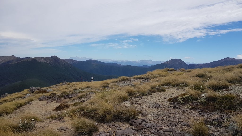
With breakfast over, we finished packing up and hit the trail again. Climbing up the hillside, we were rewarded with great views back towards the hut. The amazing views continued for most of the morning as the trail wound its way along the ridgeline above the trees. The clear sky’s made sure we got the best view possible!


Heading towards Old Man Junction, we got our first taste of the sheer drops and narrow ledges, with a few exposed sections of track to navigate where one slip or miss step could be seriously bad for your wellbeing. There was also still a bit of wind around at the tops, which made negotiating these sections more difficult than they would otherwise be.

We reached the halfway point of our day by lunchtime. Leigh had wanted to carry extra water for the entire day to save the 2km return journey off-trail down to Old Man Hut. As my pack was already too heavy and I wasn’t keen on adding extra weight, we compromised in that I would make the side trip to the hut to collect water for both of us. The trip would be quick though as I would leave my heavy pack at the top of the ridge with Leigh and take only a day pack with me to carry the water bottles back up the hill.
The descent to Old Man Hut felt like it went on forever. Carrying an empty bag, I was almost running down the hill, dodging kamikaze insects along the way that wanted to fly directly at my face for some reason. It ended up taking me longer to filter 5L of water for Leigh and myself (including time spent swatting away bumblebees) than it did to go either down or up the hill.

With our water sorted we were ready to tackle the hardest part of the day… summiting both Little Rintoul (1643m) and Mount Rintoul (1731m) in succession.

Climbing through the tree line towards Little Rintoul, we reached a rocky slope and started ascending. The terrain reminded us a bit of Tongariro, just without the boardwalks and hundreds of people.


As we climbed towards the summit of Little Rintoul the views just got better and better. We have become mountain goats of sorts… really slow ones, but we keep on climbing steadily until we reach the top.


It wasn’t until we reached the top of Little Rintoul that the fun really started though. Ahead of us was the even higher Mt Rintoul, but we would need to drop down steeply off the back of Little Rintoul before we could even start that climb. This drop also happened to be on an unstable scree slope.


The trail notes warned that this part of the trail would be challenging, but it was next level compared to anything else we had encountered on the trail so far. After moving along the top of Little Rintoul, we dropped almost straight down the steep scree slope, using hiking poles and whatever else we could grab onto to try to control our descent. Leigh was displeased with the condition of the ‘track’ to say the least. I’ve chosen not to repeat the words that were uttered that afternoon.


It certainly wasn’t graceful, but we eventually made it to the bottom after a few minor slips and slides along the way.

We were then climbing up again, this time towards Mt Rintoul. From afar the track looked epicly sketchy but it wasn’t too bad when face to face with it. At least it was a bit more solid underfoot (in most parts) than the Little Rintoul descent.


You know when a mountain goat looks surprised to see you it means you probably have no business being on the mountain. Seeing a family of mountain goats on our way up to the summit of Mt Rintoul, we definitely got that feeling.

Shortly after bidding farewell to the goats, we reached the summit. We took in the magnificent views for a while and caught our breath, knowing that another steep scree slope was waiting for us on our descent of Mt Rintoul.


At first the track along the ridge was fine but once it dropped off the other side, we were essentially sliding down the hill one step at a time rather than walking. You had to really concentrate on where you put your feet and balance to avoid slipping or falling, which was tough to do at the end of a long and demanding day.


The steep scree slope descent eventually transitioned to equally steep forest track. At the end of a 10hr hiking day you imagine the hut around every corner but it was nowhere to be found. Finally we popped out of the forest and the hut appeared, just when I was starting to think that the map must be wrong.


Turns out we were the only people staying at the hut that night, so we were able to spread out a bit in the 6 bed hut and make ourselves at home. We even had unexpectedly great views of the ocean from our kitchen window! What a life!

Day 81 – Saturday 5 January, 16km
Rintoul Hut to Mid Wairoa Hut
We started our day watching a baby and mumma goat grazing on the grass outside of our window.
From the hut, we headed into the forest, with a gradual climb back up to the edge of the tree line. After yesterday’s hill climbs, it was great to have some flat ground to walk on again. It really makes you feel like you are flying.


Our packs also feel lighter today as we have passed the halfway point on this section in terms of food carried. With only 4 days of food in our packs now, we are back down to the sorts of weights that we carried all the way across the North Island when the next supermarket was only a few days away.
Popping up above the tree line, we could for the first time see clearly back to the Mt Rintoul descent we did yesterday and it looks seriously steep from this angle. The wind picked up as we turned the corner after going past another mountain called Purple Top.


It was around this time that the track became little more than a pole in the ground every 100m or so. With so much loose rock, the track becomes a choose your own adventure. Despite the increased likelihood of rolling an ankle on this type of terrain, we both made it through injury free.


We dropped out of the wind and back into the forest on our way to Tarn Hut. The sun was seriously hot whenever the tree cover disappeared along the trail. It was along this section of trail that we had our first encounter with the wasps that we had been reading about in the hut books along the way.


For a few hundred metres along the beech forest section between Rintoul and Tarn Hut, wasps swarmed a particular type of tree. Luckily they seemed disinterested in us, but we moved quickly through anyway just in case and tried our best not too disturb them.
Reaching Tarn Hut shortly after, we stopped for lunch and topped up our water bottles while dodging yet more bumblebees. With full bellies we headed back up to the main ridgeline to continue the trail towards Mid Wairoa Hut.


Ahead of us was more forest walking and a fairly steep descent through the forest into the hut. It doesn’t matter how much walking we do through these forests of the Richmond Ranges, they are still unbelievably beautiful to walk through.


Once we reached the bottom of the steep descent, the hut was on the other side of the river, separated by a decent sized swing bridge. I took the opportunity to have a quick dip in the waters below while waiting for Leigh to reach the hut and before the sun disappeared.


The hut was already full, again, so we pitched the tent outside, again. Seems to be a better option anyway in places like this that are overrun by sandflies as it is easier to keep them out of the tent than it is to keep them out of the hut when people are opening and closing the door all the time.
Day 82 – Sunday 6 January, 17km
Mid Wairoa Hut to Hunters Hut
As per usual, the sandflies were waiting to attack us as soon as we left the safety of the tent this morning. It really is a great motivator for getting packed up and moving as quickly as possible.


The walk to Top Wairoa Hut this morning was beautiful but terrifying. There were wasps all the way along the trail through the beech forest. We saw them hanging out on trees, on rocks, and coming out of hollows in the ground. We were worried about accidentally stepping on one and creating a swarm situation.
We had a number of knee deep river crossings on this section and at one point I was walking with my pant legs rolled up after completing a crossing when I felt a sharp pain in my exposed right calf. I quickly turned around to see a wasp latched on to the back of my leg. I did what any rational person would do in that situation and slapped it off my leg with my hand as quickly and as hard as I could, while hoping that it wouldn’t sting me multiple times. Thankfully I only got the one sting and it wasn’t too painful.


With the trail following the river all morning, we decided to stop for a dip in one of the nice pools that we passed along the way. The water was freezing cold, but a great way to cool off instantly.


Leaving the river behind, we stopped off for lunch at Top Wairoa Hut, before heading into Red Hills country for the next two days.


With its distinctive red earth colour, this was spectacular country. If it wasn’t was the unbearably hot midday sun we could have taken our time to enjoy it a bit more. In a sense of deja vu, we were again climbing on loose rocks with a trail marked only by the odd pole.


Reaching the high point on the day’s trail shortly after, we were able to take in some amazing views but the wind made it clear that we weren’t welcome. We made a hasty retreat down the other side of the trail to get out of the gusty wind.


The descent from that point felt very long and indirect. We also had more scree to contend with, Leigh’s favourite walking surface. By this point, the sun and wind had sapped all of our energy and it was a real struggle to find the movitation to push on to the next hut. Especially once we reached the steep and slippery scree slope descent.


Leigh was keen to pitch the tent on the trail, but as we only had a few kms to go we continued on to Hunters Hut. We had a great night there, chatting with two guys we had met earlier in the day on the trail and a German couple that were section hiking the TA.
We were rewarded for our efforts in getting to the hut with a spectacular sunset bursting through the cloud and a roof over our heads during the rain that would fall later that night.

Day 83 – Monday 7 January, 18km
Hunters Hut to Red Hills Hut
The morning started with more of the same terrain – climbing up hills. Thankfully we had overcast skies for the duration of the climb which gave us a brief reprieve from the scorching heat of the past few days.


After starting on a proper track, we soon reached more loose boulders before heading into another waspy forest. Fun times. The track was also pretty damp in places which made for slow walking as we tried to keep our feet as dry as possible by picking the best path through the boggy track.


This then led to more scree slopes and sidling awkwardly around mountains. We were pretty over scree and half formed trail by this point. The scenery and country that we were walking through was stunningly beautiful but it wasn’t easy walking through it by any means!


Finally we spotted Porters Creek Hut in the distance and headed there for our lunch break. Porters Creek Hut was surprisingly nice and even had a bit of a skylight at the front, which was a first for the huts we have been in so far. I was feeling tired by this point and was keen for a midday nap, but Leigh was having none of it and forced me back on the trail.


It was more of the same after lunch, with a few river crossings thrown in for good measure. The water in these mountain rivers though is so clear that you can’t help but want to jump in for a swim even though you know it’s going to be painfully cold.


As the last climb for the day loomed ahead, we finished swimming in the river and headed for the hut. The afternoon heat made it tougher than it should have been but after taking our time on the climb we eventually spotted a grassy plain in the distance.

It was a nice walk through long grass to reach Red Hills Hut, our last hut on this section of the trail. It was also the newest hut we have stayed at yet, with fly screens and a more modern look.


Tomorrow we would be heading into St Arnaud, our first town in 10 days. We were pretty excited for some non-hiking food and a shower.
Day 84 – Tuesday 8 January, 20km
Red Hills Hut to St Arnaud
Our day started with a great sunrise outside of the window of the hut, and we didn’t even need to get out of bed to see it!
We had a few really fast hikers turn up late last night after we were already in bed. One arrived around 9pm and the other two around 11pm but they ended up camping outside as to not disturb us. Chatting to them this morning, they had only taken about half the time we had taken to complete the Richmond Ranges, which is seriously impressive.
We have started to notice a few people catching up to us recently who have been doing bigger days than us, both in the km’s travelled and time on the trail. Everyone has their own reason for doing the trail and their own goals but it has been interesting meeting people who maybe have different goals than we do, in that they are focused on completing the trail as quickly as possible. Still, it has been impressive to see how fit some of these people are, based on how quickly they are moving through the trail.
The walk today looked fairly straightforward on the map and trail notes. A few small hills to climb a total of about 450m, some ridge top walking and a descent of 600m down to the road. We would then have 8km of roadwalking to St Arnaud.


With the end of the Richmond Ranges in sight, my legs started to feel heavy. Every step was an effort. The climbing wasn’t overly challenging compared to what we had already been through but it felt like really slow going. In reality though, we were still moving at or slightly faster than the times estimated in the trail notes.
Thankfully the were no wasps to contend with in the beech forests today. The landscape was largely similar to that which we have been travelling through over the past few days. It wasnt until we reached a clearing in the forest that we could see down to the main road and the stunning valley that it sat within. We could feel and good meal, shower and comfy bed getting closer.

The track that we were walking on today was a joint use trail for mountain bikers, so we had to be on the look out for anyone riding in front or behind us. Being a Tuesday though, we didn’t see anyone.


We eventually reached the track/gravel road leading downhill and stopped for lunch overlooking the valley.

We arrived at the road not long after lunch and the prospect of an 8km road walk in the hot midday sun didn’t really excite us too much so we walked until we found a safe spot for a car to pull over and then stuck the thumb out. We thought we could be there for a while but it would have been less than 10 minutes before we got a hitch into St Arnaud with an Australia guy and his French friend who he was visiting in New Zealand.

With free wifi at our hotel in St Arnaud, we spent the afternoon catching up on the last 10 days we have been without phone reception since Havelock. Once the restaurant opened, we made a bee-line to get our fix of pizza, dessert and drinks.


With our stomaches full but clothes still stinky, we ended the day with a double load of washing.
The Richomd Ranges have been especially tough on our gear, but especially Leigh’s boots and shirt, both of which are staring to fall apart. We contemplated heading out to Nelson to look for replacements but we couldn’t find anywhere to stay due to a big annual event being held there, so I guess it will need to wait until we get to Christchurch now, once we reach Arthur’s Pass in about two weeks time.
Day 85 – Wednesday 9 January, 0km
Rest day
Today we spent the day in St Arnaud, relaxing and waiting for a parcel to arrive in the afternoon. We spent the day catching up on weather forecasts, trail notes for the upcoming section to Boyle Village and checking items off our individual to do lists.
We walked as far as across the road to check out the general store and order breakfast from the adjoining cafe.
Looking forward to getting back on the trail after a much needed rest and tackling the infamous Waiau Pass!

Leave a comment